Project Intelligence: Turning Real-World Sites Into Decision-Ready Data
- Derrick Campeau
- 2 days ago
- 7 min read


Construction projects generate an enormous amount of information.
The problem is that much of it is fragmented.
Site photos live in phones and email threads. Measurements are collected at different times by different people. Progress meetings rely on memory, drawings, spreadsheets and whoever happened to be on site that week. When someone needs to understand what existed at a specific location three weeks ago, the answer often requires another site visit-or simply does not exist.
Project Intelligence changes that.
By combining high-resolution aerial reality capture, 3D modelling, geospatial data, site measurements and repeatable documentation, we can turn a physical project into a measurable digital environment that teams can revisit, analyze and compare throughout construction.
The drone is simply the capture tool.
The real product is intelligence.
What Is Project Intelligence?

Project Intelligence is the process of capturing the current physical condition of a project and converting it into information that can support better decisions.
Instead of receiving a folder of aerial photographs, a project team can receive a structured package containing information such as:
Interactive 3D site models
High-resolution orthomosaics
Digital Surface Models
Current-condition topographic information
Surface elevations and contours
Visible infrastructure locations
Stockpile and material quantities
Excavation and grading information
CAD-ready site data
Time-stamped construction records
Repeat-capture progress comparisons
Together, these outputs create a much more complete picture of what is happening on a site.
More importantly, the same process can be repeated.
Capture 01 becomes the baseline.
Capture 02 shows what changed.
Capture 03 begins to reveal the actual movement of the project.
Over time, the digital record becomes increasingly valuable.
From Drone Photography to Site Intelligence
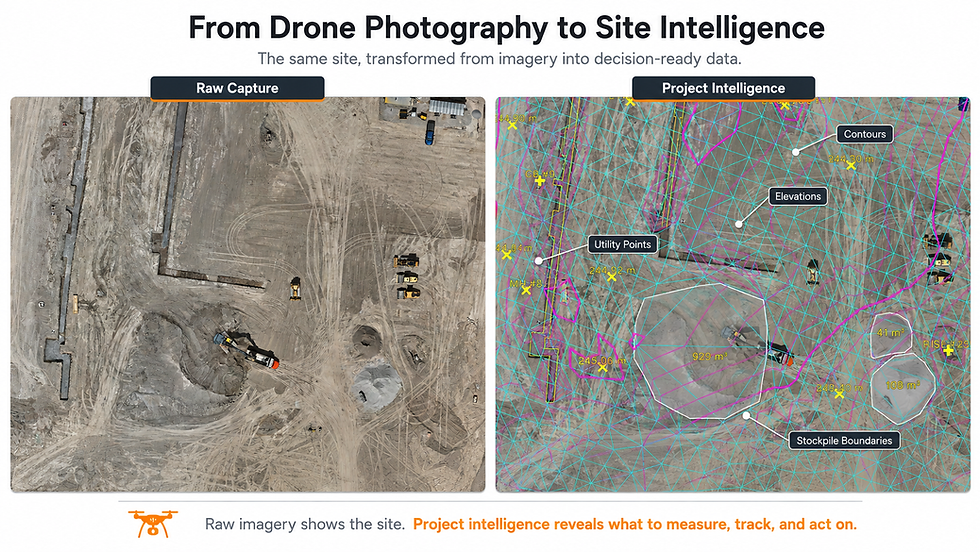
Traditional drone services often stop at imagery.
A flight is completed, photographs are processed, and the client receives an orthomosaic, a video or a 3D model.
Those products can be useful-but they leave much of the potential value untouched.
At Elev8 Visions, we approach the process differently.
We begin with a simple question:
What decisions could this data help the project team make?
That changes what gets delivered.
A high-resolution site capture can become a measurable 3D environment.
The 3D environment can produce elevations.
The elevations can generate contours.
Visible infrastructure can be extracted and documented.
Stockpiles can be measured.
Earthwork can be compared between captures.
Site conditions can be reviewed remotely.
And every capture creates a permanent time-stamped record that can be referenced later.
That is the difference between capturing a site and creating Project Intelligence.
A Digital Record of the Site

One of the most valuable parts of the process is often the simplest:
the ability to revisit the site exactly as it existed on the capture date.
Construction moves quickly.
Material disappears. Trenches are backfilled. Utilities are covered. Equipment moves. Grades change. Concrete is placed. Buildings begin to rise.
Once those conditions change, they can be difficult-or impossible-to reconstruct.
A high-resolution reality capture preserves them.
A project manager can return to the digital site weeks later and inspect an area remotely.
An estimator can reference material conditions.
A field team can review the position of visible infrastructure.
An owner can better understand progress without relying entirely on written reports.
A disagreement can be supported by a visual record of what was actually present at the time.
It becomes more than documentation.
It becomes project memory.
Interactive 3D Site Models

A 3D model creates one of the easiest ways for stakeholders to understand a project.
Instead of looking at isolated photographs, users can navigate through the entire captured environment.
Depending on the platform and project requirements, teams can:
Rotate and inspect the site
Zoom into specific work areas
Measure distances
Review spatial relationships
Compare areas of work
Share conditions with off-site stakeholders
Reference a common digital environment during discussions
This can reduce the communication gap between the field and the office.
A superintendent sees the site every day.
An owner, consultant, estimator or executive may not.
A 3D reality model gives those stakeholders a way to understand the physical project without requiring every conversation to begin with another site visit.
Current-Condition Topography

Aerial photogrammetry also allows us to derive elevation information across large areas of a project.
From this information, we can generate products such as:
Surface elevations
Contours
Terrain breaklines
High and low areas
Grading information
Drainage context
CAD-ready topographic features
This creates a current-condition representation of the site that can support planning, communication and preliminary analysis.
Where appropriate, visible site features such as maintenance holes, catch basins, access structures and exposed utility components can also be identified and documented.
The result is a much more useful dataset than aerial photography alone.
It is important to distinguish this from a legal or certified as-built survey where those services are required.
Project Intelligence is intended to supplement project teams with fast, measurable current-condition information—not replace professional survey requirements where certification is necessary.
Digital Surface Models

A Digital Surface Model, or DSM, represents the elevation of everything visible to the capture system.
That includes:
Ground
Stockpiles
Structures
Equipment
Vegetation
Temporary site features
For construction teams, a DSM becomes another layer of information that can support terrain analysis, surface comparison and quantity calculations.
When processed alongside cleaned construction surfaces and extracted features, it becomes especially powerful.
The raw DSM preserves what was physically present.
A cleaned working surface can help represent the underlying construction grade.
Together, the two datasets provide both documentation and analysis.
Stockpile and Material Intelligence

Material quantities are another area where reality capture can generate immediate value.
Where a stockpile has a clearly identifiable boundary and a defensible reference surface, its volume can be calculated directly from the captured terrain.
This allows teams to create repeatable records of material such as:
Aggregate
Soil
Sand
Granular material
Excavated material
Other bulk products
Instead of relying solely on visual estimation, a project can maintain measurable digital inventory records.
Repeat captures can then show how those quantities change over time.
That can support material management, reconciliation, progress tracking and planning.
Where Repeat Captures Become Powerful

The first capture creates information.
The second capture creates change intelligence.
Once a project is captured consistently over time, teams can begin comparing:
Grade changes
Cut and fill
Excavation progress
Stockpile growth or depletion
Foundation development
Road and access changes
Material staging
Visible infrastructure installation
Overall construction progress
This is where Project Intelligence can become part of the operating process instead of a one-time drone service.
A project can be captured:
At major milestones
Monthly
Biweekly
Weekly
Or based on specific construction events
The appropriate frequency depends on how quickly the site is changing and which decisions the data is meant to support.
Helping Teams Work Smarter and Safer
There is also a safety component.
Every question that can be answered remotely is one less reason someone may need to walk through an active work area simply to gather information.
Every broad site condition that can be reviewed digitally can reduce unnecessary exposure to moving equipment, excavation, unstable terrain and other construction hazards.
Project Intelligence does not eliminate field presence.
Construction will always require people on site.
But technology can help ensure that site visits happen because they are necessary, rather than because the information was never captured in the first place.
That is an important distinction.
A Better Way to Communicate Progress
One of the challenges in construction is that different stakeholders often understand the project at very different levels.
Field crews understand one perspective.
Project managers understand another.
Owners, consultants, executives and municipalities may see the project far less frequently.
Project Intelligence creates a common visual and measurable reference point.
Instead of saying:
“That area has been graded.”
A team can show the current terrain.
Instead of:
“We moved a lot of material.”
A team can quantify it.
Instead of:
“That structure was there before we backfilled.”
A team can return to the capture.
The more measurable the project becomes, the easier it becomes to communicate.
The Future Is Not More Drone Flights
We believe the future of aerial technology in construction is not simply more drone flights.
It is better integration of reality capture into project decision-making.
The aircraft will continue to become more capable.
Processing will become faster.
Autonomous systems will allow sites to be captured more frequently.
Artificial intelligence will help identify changes and important conditions automatically.
But the underlying objective remains the same:
Give project teams better information, faster.
That is what Project Intelligence is designed to do.
Elev8 Visions Project Intelligence
Our process is designed to turn physical sites into useful digital information.
Depending on the project, an intelligence package can include:
Reality Capture
High-resolution aerial mapping of the current site condition.
Interactive 3D Site Model
A measurable digital environment accessible to project stakeholders.
Topographic Intelligence
Surface elevations, contours, terrain features and current-condition mapping.
Infrastructure Intelligence
Locations and elevations of observable surface structures and project features.
Quantity Intelligence
Stockpile volumes, material measurements and earthwork analysis where appropriate.
Progress Intelligence
Repeat captures that show how the project changes over time.
Technical Deliverables
CAD, GIS, orthomosaic, DSM and other project-ready data formats.
The objective is not to provide every possible dataset.
It is to provide the right information for the decisions being made on the project.
See the Whole Project
Construction teams already have more data than ever.
The opportunity is to make that information easier to capture, understand and use.
Project Intelligence creates a bridge between the physical site and the digital project environment.
A measurable record of what exists.
A way to understand what changed.
And a foundation for making better decisions as the project moves forward.
Work smarter. Work safer. See the whole project.
Interested in seeing what Project Intelligence could look like on your project?
Talk to Elev8 Visions about a Site Intelligence Capture.

Comments